 Facebook
 X
X
 Pinterest
 Copy Link
Find someone about six feet tall, then imagine another six-foot-tall friend standing on their head, not their shoulders but their head. Tricky but illustrative. They’d still have to hold their breath if they stood at the low tide line. The tides around Whidbey Island can rise and fall about twelve feet. That’s a lot of water. About twice a day, the Pacific Ocean flows into Puget Sound and flows back out. And yet, it usually happens quietly.
Why do Tides happen?
The moon and the sun pull Earth’s waters around the planet. The land gets in the way. Depending on the shape of the shore and the land underwater, the water piles up and drains. In Puget Sound that’s filling a basin 100 miles long across an area of about 1,000 square miles. It all has to flow past Whidbey. Imagine the traffic jam.
Where does all the water go?
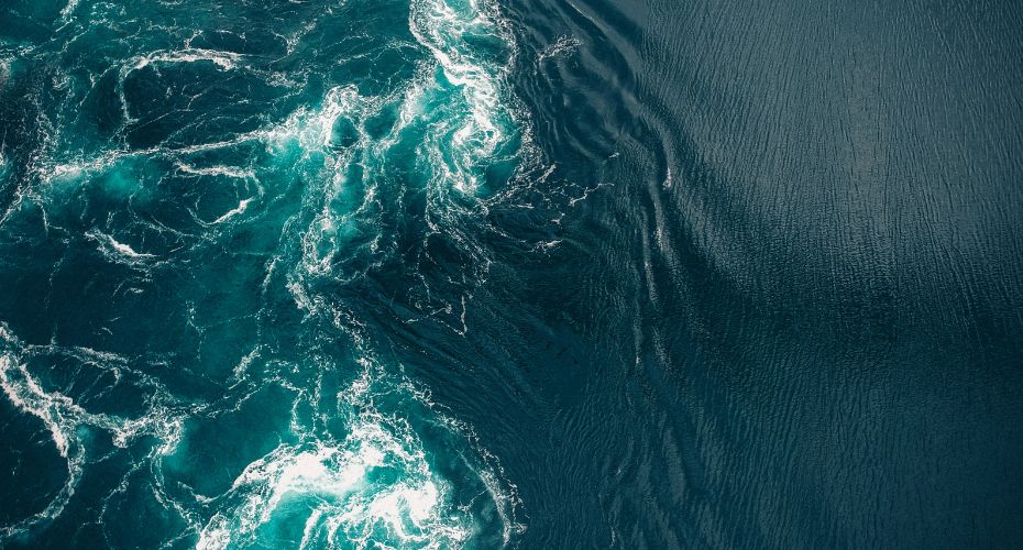
Most of the water flows past the west side of the island. Admiralty Inlet is miles across. Some goes through Deception Pass, which is much smaller, and hence the currents are much higher. Particularly at the Pass, but throughout Puget Sound, we can get white water conditions as currents scour geography, continuing the carving of the rocks and the gravels that define Whidbey’s shape. Swimmers, divers, and kayakers beware.
The currents are noticeable, but islanders are more aware of the tides. Sandy beaches can have shallow and long tidelands. Penn Cove, Dugualla Bay, Useless Bay are a few of the beaches where it can be a long walk from the high tide line out to the low tide line. Cultus Bay drains out so far that any crabs wanting to stay wet have a mile-long commute.
Where some see a lot of grey sand, birders and kids, clammers and beachcombers can find plenty to watch, play with, and harvest. Look up and watch eagles duel with osprey over fish. Long-legged heron may define the shelf before the drop-off to the Sounds’ incredible depths.
What should people be aware of?
Boaters may find themselves checking their charts for hazards, or rapidly retreating from the sound of something scraping their boat’s hull. Often enough, some boat will anchor at high tide, then find it tipping over as the water recedes. That’s one way to wake up. Fisherfolk may want to check on the depths they’re casting to. Crab pots need to stay submerged. Beach walks can be interrupted by a returning tide even trapping unassuming walkers in the worst scenarios.
Anyone setting foot out there should check whether they’ll be trying to walk on firm sand, something a bit squishier, and unfortunately, occasionally needing to be extracted from shoe-sucking muck before the tide comes back in. There are many stories of unaware tourists or newcomers getting stuck in an almost quicksand like muck. No one has lost their lives but plenty of flip-flops and shoes have been lost.
Homeowners have another perspective. Waterfront properties are considered premium, for good reason. Unobstructed views of the water and its wildlife are sweet. Being able to launch a boat from the beach can be convenient. Posting sunset or sunrise photos can make an impressive photo gallery on social media.
Homeowners pay for the privilege. Depending on their local geology, they may have to deal with seawalls, maintaining a slope, even accessing the beach in some cases can be difficult to impossible. Low-bank waterfront lots will get you to the waves a lot faster but uncomfortably so, for some.
Tides don’t always act the same way every day.
Every year there are tides that are higher and lower than normal. Near the New Year, there will be King Tides, tides that are higher than normal because of the relative position of the moon and the Earth’s tilt. Take photos, if you can. Scientists are trying to better understand how better to predict the time, size, and impact of the King Tides. They even have instructions about what to include in the photo to make it useful as data.
Storms happen, too. Storms usually happen with lower air pressure zones. Low pressure literally means less air pressure pushing down on the water. It seems like it wouldn’t have much of an effect, but check the Weather Channel’s commentary whenever an ocean storm is hitting land.
Put those last two things together and a storm surge during a King Tide can be impressive, and something to respect. Look at some of the driftwood logs that seem so far back from the waves. There’s a good chance some storm set them there. That’s a good time to be somewhere safer.
FEMA, the Federal Emergency Management Agency, has compiled data and produced maps for the nation’s coastlines because floods and storms happen. If you’re interested in a particular address or neighborhood, you can zoom in to see what the officials expect. Some areas have surprising results because some Whidbey land was wet but is now dry thanks to dikes. Bayview, which doesn’t have a view of a bay, once was an inland harbor.
Nature is wild, by nature. Waterfront views are wonderful, but that wonder takes a bit of effort to live beside responsibly. There is one solution to waterfront views that are more care-free: make sure it is fresh water. Lakeside houses don’t have to deal with tides. Their waters aren’t as dynamic, but can be equally peaceful. You just lose the bragging rights of owning something that touches the Pacific Ocean.
With so many options and such a variety of things to consider you need a shoreline and local real estate expert to navigate a purchase with confidence. Call us today and after we ask you a number of questions about your specific needs and goals we will match you with the perfect professional to guide the way!
If you are considering moving to a waterfront property, talk to your agent about how tides might affect your property. Don’t have an agent? Connect with us.
