Honeymoon Bay

Honeymoon Bay is a scenic neighborhood located on the southern end of Whidbey Island. The neighborhood is situated on the east side of the island, just south of the town of Freeland.
Why do people love Honeymoon Bay so much that they want to live there?
One of the main reasons people choose to live in Honeymoon Bay is the stunning natural beauty of the area. The neighborhood is surrounded by forests and offers picturesque views of the bay, as well as nearby mountains and islands. Additionally, the neighborhood is relatively secluded and quiet, providing a peaceful escape from the hustle and bustle of city life. While also offering a quick drive to the nearby city of Clinton to hop on a ferry to the big city when needed.
What can you do at Honeymoon Bay?
The bay itself is a popular destination for outdoor activities such as swimming, kayaking, and boating, and there are several public beaches and parks nearby.
Some of our favorites are:
The area is also home to a variety of wildlife, including eagles, otters, and seals, making it a haven for nature lovers.
Is there anything close by?
In terms of amenities, the town of Freeland is just a short drive away and offers a range of shops, restaurants, and services.
Some of our favorites are:
The nearby cities of Greenbank and Langley offer additional options for dining, shopping, and entertainment.
Overall, Honeymoon Bay is a beautiful and peaceful neighborhood that offers a unique combination of natural beauty, outdoor recreation, and small-town charm. It is a popular destination for those looking for a quieter, more relaxed lifestyle while still enjoying easy access to nearby cities and amenities.
If you are looking to call Honeymoon Bay home, do not hesitate to connect with us.
Working On Whidbey

Are you thinking of moving to Whidbey and wondering what working on Whidbey looks like? We’re not all retirees. Of Island County’s ~87,700 residents, ~28,000 residents have full-time jobs. (EDC Island County Profile 2020) The Navy accounts for ~11,000, so estimate that total at ~39,000. There are many retirees, children, and people employed part-time or not at all. One answer doesn’t fit all. Keep reading for the details.
The Navy Dominates
The Navy is the largest employer by thousands. If you live in or around Oak Harbor, they are hard not to notice. Some people in the military live as far south as Clinton. Others are quite far off-island and commute 45 minutes or more. Take a look at a map and notice the roads heading to the big blank space just north of Oak Harbor. Not everyone working on base are military personnel. Military bases tend to have a little bit of everything, including jobs for civilians. The base is why the Island’s population is concentrated on the north part of the island. It is also the reason there are so many businesses and jobs around it.
Airplanes Need Built
Ironically, the next biggest employer of islanders is also dealing in airplanes but is not on the Island. Boeing’s Everett plant builds the wide-body jet airplanes people are familiar with. Approximately 900 Boeing employees commute to the plant. That’s more than four times the number Walmart employs on the Island, and no on-island business is bigger. Boeing is only one example of off-island employers with island commuters. Over 35% of Island County’s employees leave the county to get to work. Some may have switched to “Work From Home”, but those jobs are in flux as employers and employees maneuver around each other while trying to find that remote vs. on-site balance.
Keep in mind, much of this data includes Camano Island because the government reports cluster data by county, as in Island County, rather than by geography, as in by island.
So, where is everyone else working on Whidbey?
As we noted, the Navy dominates with 63% of the workforce. The next biggest batch is 20% from governmental jobs like schools, city, county, state employees and hospitals. Then comes the private companies. The ones with more than ~50 employees add up to ~17%. Those three segments add up to ~100% but miss a large contingent that is harder to track. The number of people employed by small companies and entrepreneurs is about 6,000.
Understanding what works on Whidbey is different from what works in more conventional places, like big cities. Island County is officially designated as a rural county. Farm payrolls shift dramatically. Whidbey Island also has officially declared spaces that are Creative Districts. Wander around Whidbey and notice the many artists, studios, galleries, public displays, events, and performances. They also have supporting businesses supplying them with supplies, services, marketing, and such. Artists and farmers are so busy tending their projects and fields, and tend to be soloists, which means dutifully reporting data easily gets out-prioritized.
Is remote working on Whidbey a possibility?
While remote work may be a new thing for much of the world, Whidbey has also held a population of people who live here and commute to the rest of the world. Negotiating a deal in Kuala Lumpur? Your house address isn’t as important as having an airport available. Thanks to the Island’s connections, SeaTac (south of Seattle), Paine Field (close to the Clinton Ferry), and Bellingham’s international airport, a flight can be a drive, bus ride, or shuttle trip away. Canada’s even close enough that some will fly out of Vancouver’s airports when the flights are right. It is hard to track such travelers because they may be employed anywhere.
Sometimes the employers come to us, like when a movie or ad is being filmed here, or a retreat is being hosted here.
It is too easy to label such a big island with the impact of one employer. The Island has hundreds, thousands. We even have a boat builder and a few colleges.
And, of course, people move here and bring their businesses with them, or move here, and the island inspires their next enterprise.
But, retirement, or at least a sabbatical, that can work well for Whidbey too.
For a more in depth look at the data you might like to geek out on the Economic Development Council’s Island County Profile for 2020 by clicking here.
If you are considering a move to Whidbey and would like to discuss this in more detail and are not currently working with an agent connect with us to start the conversation.
A Trip Through Whidbey’s History
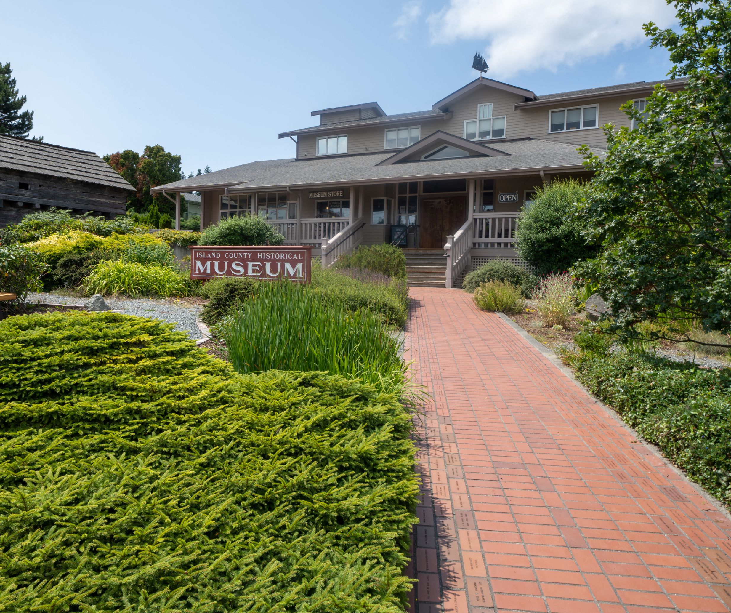
Whidbey has history? It must; there are museums here. Compared to any place in Europe it can seem that there’s no real history here; but, Whidbey has had visitors for thousands of years. Follow along with us as we take a trip through Whidbey’s history.
The island was built from some of the newest geology:
The west coast of North America was originally at Spokane, but tectonic plates moved and eventually some small ones slammed into the continent. That’s where “The Rock” gets its rocks. They hold up our bridge. Further south on the island could arguably be called “The Gravel” because a series of glaciers and ice sheets scraped mountains down to bits. Those bits were dumped into moraines and stream beds that help explain the south end’s hilly roads, as well as some of the slopes that slide.
About 16,900 years ago, those ice sheets finally left. Over 2,000 feet of ice retreated, leaving lands that waited for something to drop by and grow. The plants began to grow providing forests and prairies. The whales, fish, birds, and land creatures arrived. Today you can walk the beach and you may find mammoth teeth and bones (not a joke).
People came soon after:
They didn’t call it Whidbey. One name that became associated with the place was Tscha-kole-chy. Ask the Tulalip tribes or a local historian about how to pronounce it.
The island became populated just like the rest of the Salish Sea lands. There was food, a good climate, and relative safety from things like volcanoes.
Humans were busy for over ten thousand years, but we have few stories considering how long that period lasted. One good view of that life is the Maiden of Deception Pass sculpture and description.
Skip ahead a few thousands of years to when more people started showing up.
In the late 1700s:
European explorers sailed in. They were to explore the island and discover what existed here, a very natural and human endeavor. Captain Vancouver’s crew named many of the features. The features already had names, but now they had newer names.
1792:
Joseph Whidbey circumnavigated the island. Originally, they thought it was a peninsula, but when they completed their counter-clockwise trip and found the pass they were surprised it was an island, hence Deception Pass.
By 1848:
Some settlers tried settling on the west side of island, near Penn Cove. Thomas Glasgow, Antonio Rabbeson, and A. Carnefix established a farmstead. It didn’t last long. Local tribes were upset in general with settlers throughout the Puget Sound region. The settlers were encouraged to leave, which they did, without even taking many of their tools.
There was some disagreement between the Spanish, the British, and the pesky Americans as to who owned what. The original inhabitants had their perspective, of course. The various negotiations and treaties are complicated and fascinating. One place to start is with the Pig War on San Juan Island, a seemingly silly disagreement that almost started a real war.
The 1850’s:
Soon after, more settlers arrived. They too saw the value of the forests, farming, and fishing. Coupeville got started in the 1850s, and became the second oldest town in Washington State. The south end towns were quieter; but, Maxwelton had a 3,000 seat auditorium, for a while. The site of Bailey’s store was basically a trading post in the 1850s. Oak Harbor started then, too; and was incorporated in the 1910s.
The island was fractured. There were few roads. The main way to get around was by boat or walking the beaches at low tide.
It was about this time that Ebey’s tale became history, a fascinating story of someone who regularly rowed to Port Townsend, and then was killed over a misunderstanding. Check out the links at the end of this article if you would like to learn more about this story.
The next few decades were a bit rough, but profitable for some. Seattle was growing and it became the destination for island food and lumber. Some of the island’s tallest trees became masts for that era’s tall ships. The branches went into the growing steamship fleet’s boilers, as well as into the landfills that became Seattle’s waterfront.
Throughout those decades ships turned from oars or paddles, to sail, to steam, to internal combustion (to electric?).
Ships operated before docks were built. Some ran up onto the beach, got rid of cargo and passengers, picked up more, and backed away before the tide stranded them. A ferry carried people across Deception Pass, before the bridge was built.
1897:
The construction of Fort Casey began. After one world war it became obvious that the country needed defenses. The Navy established its base, and added and shifted as technology changed warfare. Look at the guns at Fort Casey and compare them to the fortifications at Fort Ebey to see a great change in a short time.
Boeing was busy during World War Two, but it was a few decades later that their plant at Paine Field became a major employer. Thanks to the ferries, Whidbey also became a bedroom community.
1900’s:
Meanwhile, after the start of the 20th century, Freeland was started as a place for free land, an experimental community that blended and contrasted socialist and capitalistic principles. Eventually, the culture tended to a more conventional style of community.
In 1919:
Ferries began docking at docks on south Whidbey, not just running up on beaches, and it became possible to ferry cars and trucks onto the island. They probably had wait lines and cancellations, too.
In 1920:
Langley became one of the first cities in America to have an all-women government. They inaugurated a series of reforms that cleaned up the town, literally.
About that time, some of the other rough edges of Whidbey were softened as artists began using the island as a retreat and refuge.
Thanks to fishing resorts, Whidbey was already gaining a reputation as a place to get away from The Big City of Seattle. Tourism got a beachhead.
It became obvious to some that Whidbey’s relationship with Seattle could be like the East Coast’s tourist towns relationship between cities like New York and the Hamptons. That tourist traffic became yet another reason to justify the Deception Pass Bridge.
Life in general became easier as the entire island was finally connected with roads and power.
1990’s:
By the end of the 90s, Whidbey was already known for its various communities: farming, the arts, for tourists, for commuters, and for retirees. Currently, it is being redefined again as Whidbey’s rise from obscurity has grown into an international destination for tourism and training.
What’s next? Being remote is redefining itself. Whidbey Island is being ‘found’. De-urbanization means urban dwellers are trading that lifestyle for something quieter and slower with a bit more room. But, what’s really next? That’s what every resident and visitor and fan gets to help redefine. History never ends. Welcome to this chapter, the one that you are in. What history will you create?
Connect with us whether you already live here, visit often, or want to move here.
Retirement in your future?

If retirement is in your near future, or perhaps you are already there (congratulations) you may find yourself wondering if staying in your home is still a good fit. When you live in a home for an extended period, it is normal for your needs to change as you progress through life’s milestones. You may find that your home is too big for the needs of this next chapter. Perhaps you have always had a dream destination in mind, whether to visit or to live or maybe you just want to be closer to family. Selling your home may just be the key to moving onto something that fits your life better.
Regardless of your why, understanding your options and the market can help you make the best next decision. We cannot stress enough that no one size fits all and suggest discussing your unique situation with a trusted Realtor. If you are not currently working with a realtor, connect with us. We will help find you the perfect match through a series of specific questions.
Follow along as we discuss why you might be in an advantageous position if you ARE considering a move and thinking about retirement.
Consideration 1: How long have you owned your home?
Today, people are living in their homes longer than they ever have in the past. The longer you live in the home the more likely that you are in a better position to sell. Let’s look at a few factors. The National Association of Realtors (NAR) shared that homeowners owned their homes for an average of six years between 1985 and 2008 whereas homeowners have been staying in their homes for an average of 9.2 years since 2009. See the graph below.

If you are like most homeowners today, you have been in your home for well over 5 years. If this is the case, it is an indicator that a move may be in your favor. Typically speaking, you have built significant equity after just 5 years in your home due to home price appreciation. The Federal Housing Finance Agency (FHFA) demonstrates this in their graph below.

If you have lived in your home for over 5 years, you might just be sitting on a large sum of money that could make your dreams a reality. The recent market has helped homeowners increase their equity by nearly 60% in the past 5 years. Those who have owned their homes since 1991 have experienced their home triple in value since they purchased it back in 1991.
Consideration 2: The Market
Currently, we are experiencing a sellers’ market. Home price appreciation is stable. There is a lack of inventory and a prediction that mortgage rates will decline. We have already begun to see the decline in rates. As rates drop, homeownership becomes an attainable option again for those looking to buy. If you are not currently working with an agent and would like to discuss a strategic plan, connect with us here.
Whether you wish to downsize, move to the destination of your dreams, have the funds to go on the vacation of a lifetime, or move closer to the ones you love, the equity in your home can help get you there.
No matter what your home goals are, a trusted realtor can help you discover the best options to get you there. They can help you sell your current home and get you into the that is right for life today.
Retirement in your future? Let’s connect and explore your options.
Keeping Saltwater In Its Place

Saltwater defines Whidbey Island. We’re surrounded by it. Islands in the ocean are like that. We humans need freshwater, water without the salt. Therefore, keeping saltwater in its place is crucial for survival. Fortunately, Whidbey has freshwater, too. Freshwater flowing into saltwater isn’t usually a problem. The trick is to make sure the flow doesn’t go the other way.
Congratulations if you’re on city water in Oak Harbor
Your water might be coming from off-island. Thanks to Anacortes and the Skagit River, some of Whidbey’s water is piped in from a river that starts in the mountains. Depending on the time of year, you could be drinking recently melted snow. There is not much threat of salt in that water, though there may be minerals, at least at the source.
Look at a map of the island with all its wells marked
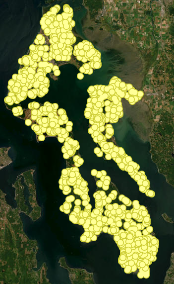
The image is carpeted with icons. For an interactive map click here. Barely any land is left to look at. Dots everywhere. That’s OK. Well water is ubiquitous. Many homes get water from community and municipal wells. Living there can feel no different than the piped water in Oak Harbor, it’s just that the pipe doesn’t have to run as far. One indication that something is different is a sign at the neighborhood’s border that announces whether the water supply is Normal or whether there’s rationing. Droughts happen.
Homeowners in more remote places can have an intimate awareness of their water supply because they have a well on their property. Nicer wells get to live in little houses and sheds that are usually far removed from the house, the septic system, and any other buildings. Here’s where there’s a possible mixing of the waters.
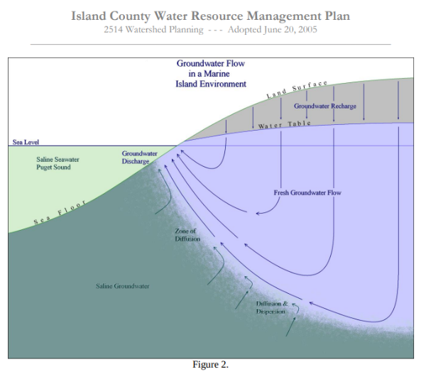
Naturally, rainwater falls, and either runs off the land or seeps through it. Rivers and streams are obvious runoff avenues, but sometimes the rainwater is just below the surface. It still flows, but in broad swathes, not as rivers or streams. Water also seeps deeper, flowing into and filling underground aquifers. It is those aquifers that wells drill into.
What are aquifers?
Aquifers are the unseen reservoirs and streams that collect and channel rainwater naturally. That isn’t just an island thing. Farms in the Great Plains drill into massive aquifers. Island aquifers are smaller. They are also a bit of a mystery. What kind of soil are they under and in? How big is it? How deep is it? How much water is in it? Is there more than one?
Hence, the drilling. For decades, residents who want to build on some land have had to check with the County about whether there is already a well, or maybe one they can try to share, or whether they’ll have to hire a well-digger – and hope.
Why all of this prelude and background?
Each aquifer has a limit to how much water can be drawn from it. It may seem obvious in retrospect, but pump out enough fresh water, and the surrounding saltwater can be drawn in, too. Voila or oops, a fresh water supply can run dry, or turning on a tap pours out salty water.
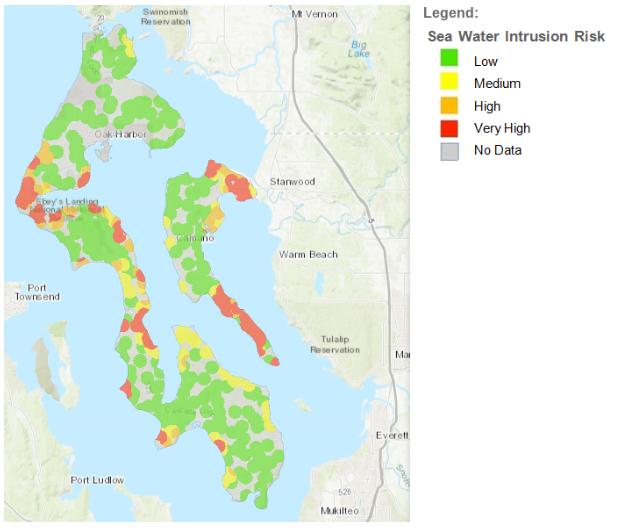
Saltwater coming up a freshwater well was less likely for the early settlers. It could happen if a well was drilled too close to the shore, especially if it was a shallow well. Seawater intrusion is no longer abstract. Look at a map of the island. Click here for an interactive map. A scattering of spots are marked as at risk of seawater intrusion. Some are already experiencing it.
Considerations when purchasing land or a new home
Risk of seawater intrusion can be one reason a neighborhood has to curtail further development. Vacant land can look enticing, but if it can’t access water, then it probably can’t have a livable house built on it. The term ‘water shares’ comes up. So do fees for tapping into restricted supplies. Drilling another well won’t work because it could pull in more of the sea.
Whidbey’s highest point is about 500 feet above sea level. Some wells have drilled so deep that they are hundreds of feet below sea level. And yet, when done right, with the right aquifer, pumped at below a specified rate, there may be no problem. Enjoy your freshwater but, analyzing that map with your broker will help ensure you know where there are concerns and restrictions.
Are there other reasons the water tastes different?
Of course, seawater intrusion is not always the reason water tastes different. Well water is natural. Minerals in the ground are natural. Drinking from an underground aquifer can be flavored by the minerals the water has seeped through. Chefs, cooks, and foodies take note when using natural water and its natural flavorings. It might be an improvement or a reason to buy or get deliveries of filtered water. Some of the minerals and hardness of island water comes from these elements: Arsenic, Calcium, Chloride, Hardness, Iron, Potassium, Magnesium, Manganese, Nitrate, Phosphorus, Sodium, and Sulfate. Household systems can be installed to make the water better match your preferences. Some are as simple as a countertop pitcher with a filter. Others can be systems occupying separate sheds because they’re larger or noisier than an owner wants in the house. Ask your broker who they recommend calling for help.
Are you curious about what’s in your water?
Private and public organizations can test for various chemicals. Your sensitivities will influence your assessment of the water’s quality. Have you ever been encouraged to drink the water as a part of your home inspection? Or even when deciding to write an offer on a property? You should on Whidbey!
The good news is that we know a lot more now than we did before. Within the last few decades, the government has been able to better measure and assess the situation. Guesses are being replaced with answers. Technologies and techniques are being developed that ease the probability of sucking in seawater.
The other good news is that some common sense can make things easier. If the sign says the levels are low, adjust your usage until they recover. It rains here, you know. Trust the rain to water a lawn. Letting your lawn go golden during our dry spells is normal. (Bonus: Less mowing!) Rain catchment systems are gaining acceptance. At the most basic level, use less water. You can benefit, and so can your neighbors.
If you are curious about learning more, or are looking to buy and not currently represented by an agent and would like to work with an agent with extensive knowledge on aquifers and our island connect with us.

 Facebook
 X
X
 Pinterest
 Copy Link