 Facebook
 X
X
 Pinterest
 Copy Link
Tides around Whidbey

Find someone about six feet tall, then imagine another six-foot-tall friend standing on their head, not their shoulders but their head. Tricky but illustrative. They’d still have to hold their breath if they stood at the low tide line. The tides around Whidbey Island can rise and fall about twelve feet. That’s a lot of water. About twice a day, the Pacific Ocean flows into Puget Sound and flows back out. And yet, it usually happens quietly.
Why do Tides happen?
The moon and the sun pull Earth’s waters around the planet. The land gets in the way. Depending on the shape of the shore and the land underwater, the water piles up and drains. In Puget Sound that’s filling a basin 100 miles long across an area of about 1,000 square miles. It all has to flow past Whidbey. Imagine the traffic jam.
Where does all the water go?
Most of the water flows past the west side of the island. Admiralty Inlet is miles across. Some goes through Deception Pass, which is much smaller, and hence the currents are much higher. Particularly at the Pass, but throughout Puget Sound, we can get white water conditions as currents scour geography, continuing the carving of the rocks and the gravels that define Whidbey’s shape. Swimmers, divers, and kayakers beware.
The currents are noticeable, but islanders are more aware of the tides. Sandy beaches can have shallow and long tidelands. Penn Cove, Dugualla Bay, Useless Bay are a few of the beaches where it can be a long walk from the high tide line out to the low tide line. Cultus Bay drains out so far that any crabs wanting to stay wet have a mile-long commute.
Where some see a lot of grey sand, birders and kids, clammers and beachcombers can find plenty to watch, play with, and harvest. Look up and watch eagles duel with osprey over fish. Long-legged heron may define the shelf before the drop-off to the Sounds’ incredible depths.
What should people be aware of?
Boaters may find themselves checking their charts for hazards, or rapidly retreating from the sound of something scraping their boat’s hull. Often enough, some boat will anchor at high tide, then find it tipping over as the water recedes. That’s one way to wake up. Fisherfolk may want to check on the depths they’re casting to. Crab pots need to stay submerged. Beach walks can be interrupted by a returning tide even trapping unassuming walkers in the worst scenarios.
Anyone setting foot out there should check whether they’ll be trying to walk on firm sand, something a bit squishier, and unfortunately, occasionally needing to be extracted from shoe-sucking muck before the tide comes back in. There are many stories of unaware tourists or newcomers getting stuck in an almost quicksand like muck. No one has lost their lives but plenty of flip-flops and shoes have been lost.
Homeowners have another perspective. Waterfront properties are considered premium, for good reason. Unobstructed views of the water and its wildlife are sweet. Being able to launch a boat from the beach can be convenient. Posting sunset or sunrise photos can make an impressive photo gallery on social media.
Homeowners pay for the privilege. Depending on their local geology, they may have to deal with seawalls, maintaining a slope, even accessing the beach in some cases can be difficult to impossible. Low-bank waterfront lots will get you to the waves a lot faster but uncomfortably so, for some.
Tides don’t always act the same way every day.
Every year there are tides that are higher and lower than normal. Near the New Year, there will be King Tides, tides that are higher than normal because of the relative position of the moon and the Earth’s tilt. Take photos, if you can. Scientists are trying to better understand how better to predict the time, size, and impact of the King Tides. They even have instructions about what to include in the photo to make it useful as data.
Storms happen, too. Storms usually happen with lower air pressure zones. Low pressure literally means less air pressure pushing down on the water. It seems like it wouldn’t have much of an effect, but check the Weather Channel’s commentary whenever an ocean storm is hitting land.
Put those last two things together and a storm surge during a King Tide can be impressive, and something to respect. Look at some of the driftwood logs that seem so far back from the waves. There’s a good chance some storm set them there. That’s a good time to be somewhere safer.
FEMA, the Federal Emergency Management Agency, has compiled data and produced maps for the nation’s coastlines because floods and storms happen. If you’re interested in a particular address or neighborhood, you can zoom in to see what the officials expect. Some areas have surprising results because some Whidbey land was wet but is now dry thanks to dikes. Bayview, which doesn’t have a view of a bay, once was an inland harbor.
Nature is wild, by nature. Waterfront views are wonderful, but that wonder takes a bit of effort to live beside responsibly. There is one solution to waterfront views that are more care-free: make sure it is fresh water. Lakeside houses don’t have to deal with tides. Their waters aren’t as dynamic, but can be equally peaceful. You just lose the bragging rights of owning something that touches the Pacific Ocean.
With so many options and such a variety of things to consider you need a shoreline and local real estate expert to navigate a purchase with confidence. Call us today and after we ask you a number of questions about your specific needs and goals we will match you with the perfect professional to guide the way!
If you are considering moving to a waterfront property, talk to your agent about how tides might affect your property. Don’t have an agent? Connect with us.
Keeping Saltwater In Its Place

Saltwater defines Whidbey Island. We’re surrounded by it. Islands in the ocean are like that. We humans need freshwater, water without the salt. Therefore, keeping saltwater in its place is crucial for survival. Fortunately, Whidbey has freshwater, too. Freshwater flowing into saltwater isn’t usually a problem. The trick is to make sure the flow doesn’t go the other way.
Congratulations if you’re on city water in Oak Harbor
Your water might be coming from off-island. Thanks to Anacortes and the Skagit River, some of Whidbey’s water is piped in from a river that starts in the mountains. Depending on the time of year, you could be drinking recently melted snow. There is not much threat of salt in that water, though there may be minerals, at least at the source.
Look at a map of the island with all its wells marked
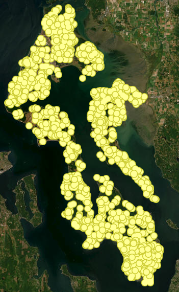
The image is carpeted with icons. For an interactive map click here. Barely any land is left to look at. Dots everywhere. That’s OK. Well water is ubiquitous. Many homes get water from community and municipal wells. Living there can feel no different than the piped water in Oak Harbor, it’s just that the pipe doesn’t have to run as far. One indication that something is different is a sign at the neighborhood’s border that announces whether the water supply is Normal or whether there’s rationing. Droughts happen.
Homeowners in more remote places can have an intimate awareness of their water supply because they have a well on their property. Nicer wells get to live in little houses and sheds that are usually far removed from the house, the septic system, and any other buildings. Here’s where there’s a possible mixing of the waters.
Naturally, rainwater falls, and either runs off the land or seeps through it. Rivers and streams are obvious runoff avenues, but sometimes the rainwater is just below the surface. It still flows, but in broad swathes, not as rivers or streams. Water also seeps deeper, flowing into and filling underground aquifers. It is those aquifers that wells drill into.
What are aquifers?
Aquifers are the unseen reservoirs and streams that collect and channel rainwater naturally. That isn’t just an island thing. Farms in the Great Plains drill into massive aquifers. Island aquifers are smaller. They are also a bit of a mystery. What kind of soil are they under and in? How big is it? How deep is it? How much water is in it? Is there more than one?
Hence, the drilling. For decades, residents who want to build on some land have had to check with the County about whether there is already a well, or maybe one they can try to share, or whether they’ll have to hire a well-digger – and hope.
Why all of this prelude and background?
Each aquifer has a limit to how much water can be drawn from it. It may seem obvious in retrospect, but pump out enough fresh water, and the surrounding saltwater can be drawn in, too. Voila or oops, a fresh water supply can run dry, or turning on a tap pours out salty water.
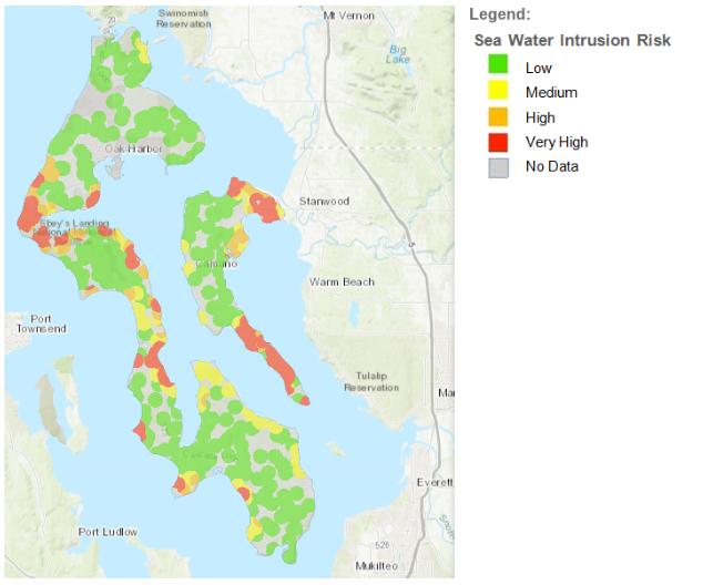
Saltwater coming up a freshwater well was less likely for the early settlers. It could happen if a well was drilled too close to the shore, especially if it was a shallow well. Seawater intrusion is no longer abstract. Look at a map of the island. Click here for an interactive map. A scattering of spots are marked as at risk of seawater intrusion. Some are already experiencing it.
Considerations when purchasing land or a new home
Risk of seawater intrusion can be one reason a neighborhood has to curtail further development. Vacant land can look enticing, but if it can’t access water, then it probably can’t have a livable house built on it. The term ‘water shares’ comes up. So do fees for tapping into restricted supplies. Drilling another well won’t work because it could pull in more of the sea.
Whidbey’s highest point is about 500 feet above sea level. Some wells have drilled so deep that they are hundreds of feet below sea level. And yet, when done right, with the right aquifer, pumped at below a specified rate, there may be no problem. Enjoy your freshwater but, analyzing that map with your broker will help ensure you know where there are concerns and restrictions.
Are there other reasons the water tastes different?
Of course, seawater intrusion is not always the reason water tastes different. Well water is natural. Minerals in the ground are natural. Drinking from an underground aquifer can be flavored by the minerals the water has seeped through. Chefs, cooks, and foodies take note when using natural water and its natural flavorings. It might be an improvement or a reason to buy or get deliveries of filtered water. Some of the minerals and hardness of island water comes from these elements: Arsenic, Calcium, Chloride, Hardness, Iron, Potassium, Magnesium, Manganese, Nitrate, Phosphorus, Sodium, and Sulfate. Household systems can be installed to make the water better match your preferences. Some are as simple as a countertop pitcher with a filter. Others can be systems occupying separate sheds because they’re larger or noisier than an owner wants in the house. Ask your broker who they recommend calling for help.
Are you curious about what’s in your water?
Private and public organizations can test for various chemicals. Your sensitivities will influence your assessment of the water’s quality. Have you ever been encouraged to drink the water as a part of your home inspection? Or even when deciding to write an offer on a property? You should on Whidbey!
The good news is that we know a lot more now than we did before. Within the last few decades, the government has been able to better measure and assess the situation. Guesses are being replaced with answers. Technologies and techniques are being developed that ease the probability of sucking in seawater.
The other good news is that some common sense can make things easier. If the sign says the levels are low, adjust your usage until they recover. It rains here, you know. Trust the rain to water a lawn. Letting your lawn go golden during our dry spells is normal. (Bonus: Less mowing!) Rain catchment systems are gaining acceptance. At the most basic level, use less water. You can benefit, and so can your neighbors.
If you are curious about learning more, or are looking to buy and not currently represented by an agent and would like to work with an agent with extensive knowledge on aquifers and our island connect with us.
Graffiti Wall West Beach
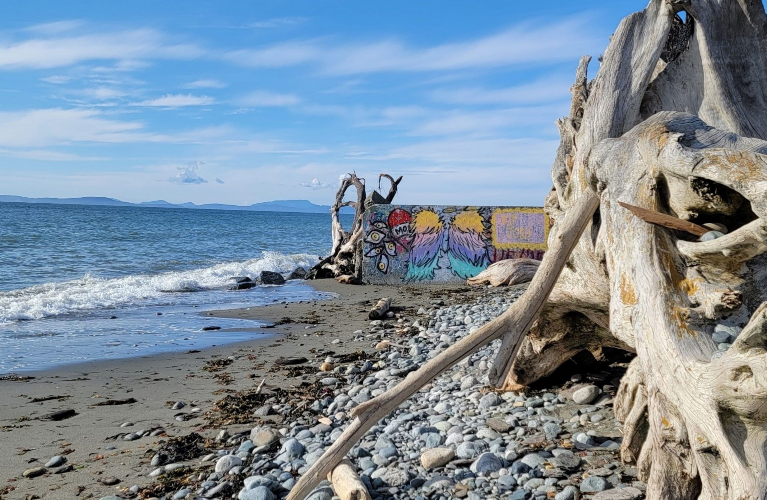
Some call it graffiti while others call it art. Regardless, this iconic Whidbey Island slab of cement that sits perpendicular to the water on West Beach has become quite popular. Next to the West Beach County Park, it is the remains of a mostly washed away Bulkhead. Now, passers-by can enjoy an ever-changing canvas of creativity. While some find it an eyesore and would argue for it to be removed others find it their next photo-op. The destruction of the concrete seawall is a reminder of just how powerful mother nature is. It’s only taken a few years of storms for her to reclaim what was attempted. Winter storms are another attraction to this area. You can watch the onslaught of waves and wind as your car gets drenched in sea spray and flying ocean foam from the comfort of your car.
Check out more about the photographer here.
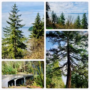
Check out the rest of Whidbey’s beautiful destinations from this series here.

Clinton Ferry
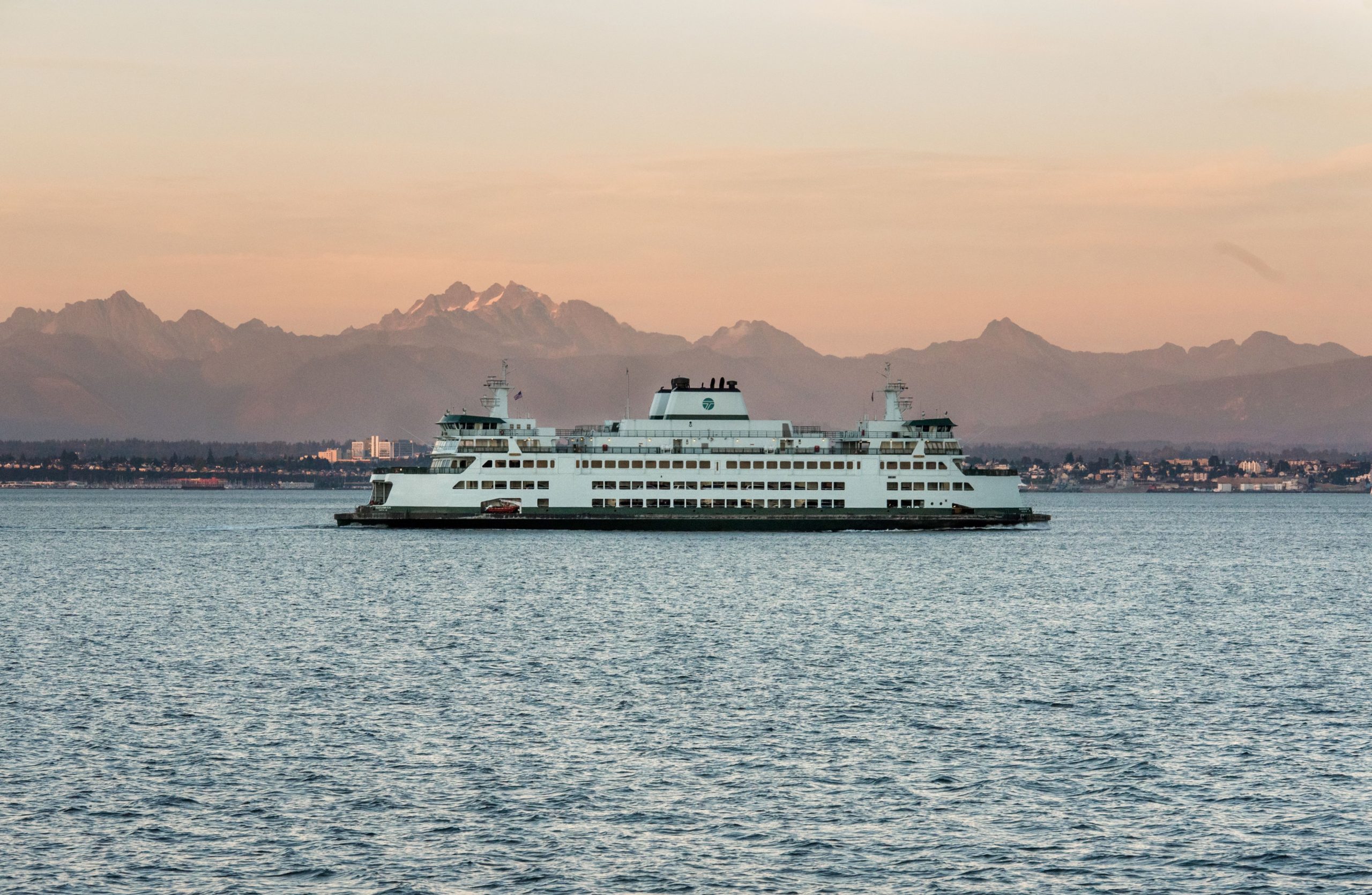
It is often a wish come true to live on Whidbey Island. With the ideal four-season experience, a marine island climate, great community culture, stunning beaches, and gorgeous scenery, what’s not to love? Unlike most islands, with access limited by expensive boat rides or planes, Whidbey Island offers three main points of access on and off the island. The beautiful Deception Pass bridge at the north end of the Island, the Port Townsend Ferry from Coupeville, and also the Clinton/Mukilteo Ferry (pictured above) with the gorgeous mountain views to enjoy during the short ride over to the mainland.
Check out the rest of Whidbey’s beautiful destinations from this series here.
Lake Hancock
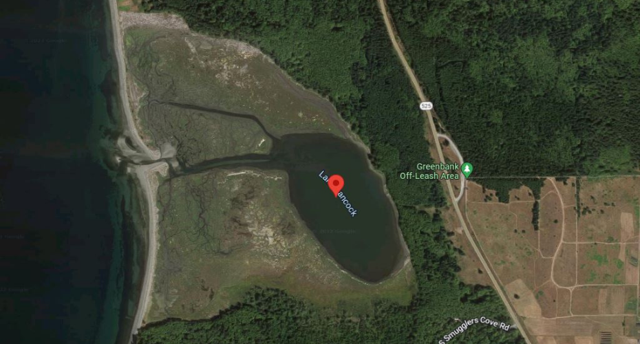
A major storm in the early 1900s destroyed a sand dune that separated the fresh water in Lake Hancock located in Greenbank from the saltwater of the Puget Sound. The destruction of the sand dune resulted in a tidal flow that sometimes creates the illusion of a flooded lake and other times leaves a stretch of muck littered with driftwood.
Lake Hancock Years Ago:
Around the time of World War II, the Navy utilized this location for bombing practice. Since the lake, still owned by the Navy, is littered with metal fragments, and there is a possibility of unexploded ordinance, access to the lake is limited to special permission escorted by Navy representatives. Bordering the southern and eastern sides of the lake is property owned by The Nature Conservancy, Island County, and the Port of Coupeville. Private property borders the most northern side of the lake and of course the Puget Sound to the west.
Today:
Due to the limited access, Lake Hancock offers a remarkable sanctuary for Whidbey Island wildlife. Parallel to the lake across the 525 is the stunning Greenbank off-leash dog area (learn more about it here) where you can catch glimpses both of Lake Hancock from one side and the Saratoga Passage on the other from the peak of the hillside. It is likely you will also discover people enjoying bird watching as this location offers some of the most extraordinary opportunities. Approximately 2 minutes south of the dog park is the lovey Greenbank Farm (learn more about it here) where you can stop for a cup of coffee and enjoy a slice of the most delightful pie made by Whidbey Pies while you are there.
Don’t forget to post a picture of your visit and tag us in it. We would love to see your adventure.
Instagram: @windermere_whidbey_island
Facebook: @WindermereWhidbeyIsland
If you are considering buying or selling and would like to learn more about the area, we would be happy to schedule a consult with you. Call us today at 360.675.5953 or email us at whidbeycommunications@windermere.com.
Penn Cove Mussel Rafts
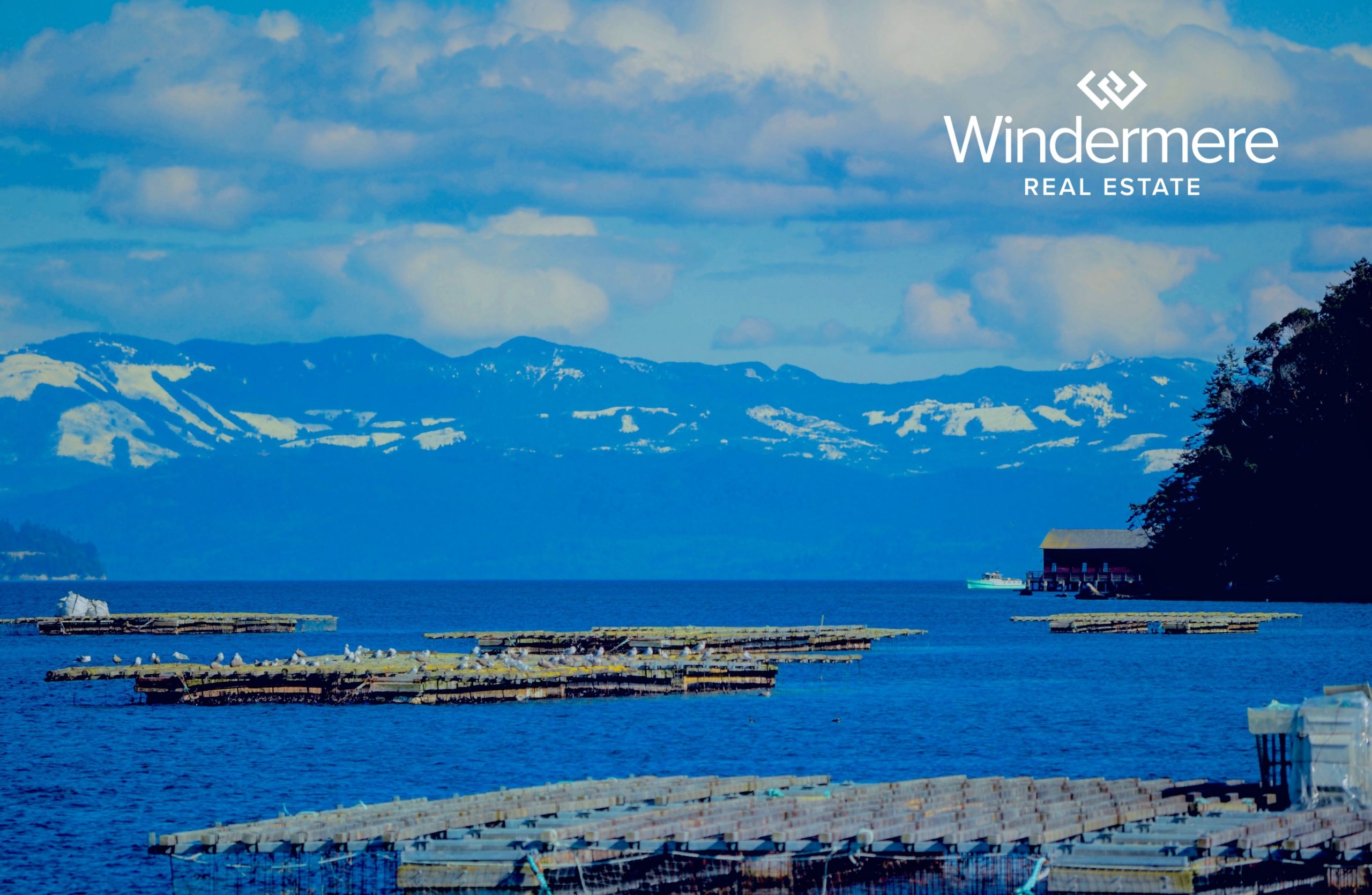
Gracing the waters of Penn Cove floats a particularly unique & quite famous feature of our island. Wood & rope intertwine to create seemingly countless rafts bobbing on the waves above and creating magic below… You may not know this, but Island county is home to the oldest & largest mussel farm in the United States. Penn Cove Mussels, Inc. began culturing mussels in 1975 with the desire to harness the cove’s naturally nutrient-rich water to harvest bigger and better mussels than the ones currently available on the market. The results were incredible! Penn Cove mussels grow at a remarkable rate, enabling the mussels to reach harvest size within one year. This rapid growth rate causes Penn Cove mussels to have a firmer texture, sweeter flavor, and a thinner shell with more meat. These crowd-pleasing mussels are a favorite of chefs all over the country and with only two hours separating Penn Cove from the Sea-Tac Airport; mussels harvested in the morning are easily on dinner plates in Houston by the evening. To read more about this local aquaculture visit our blog here.
Follow the photographer on Instagram @abhithapa.art
Check out the rest of Whidbey’s beautiful destinations from this series here.
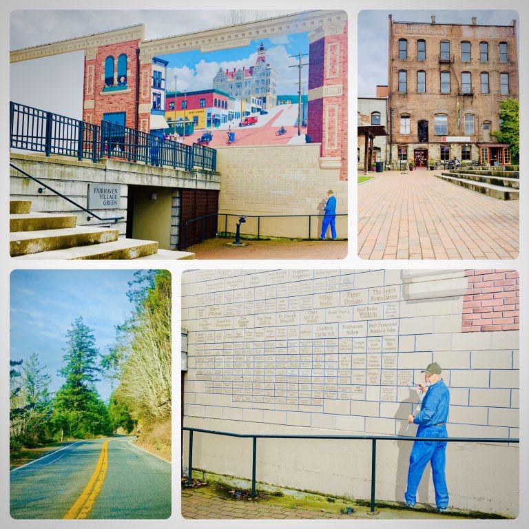
Chuckanut Drive – A Detour Worth Taking
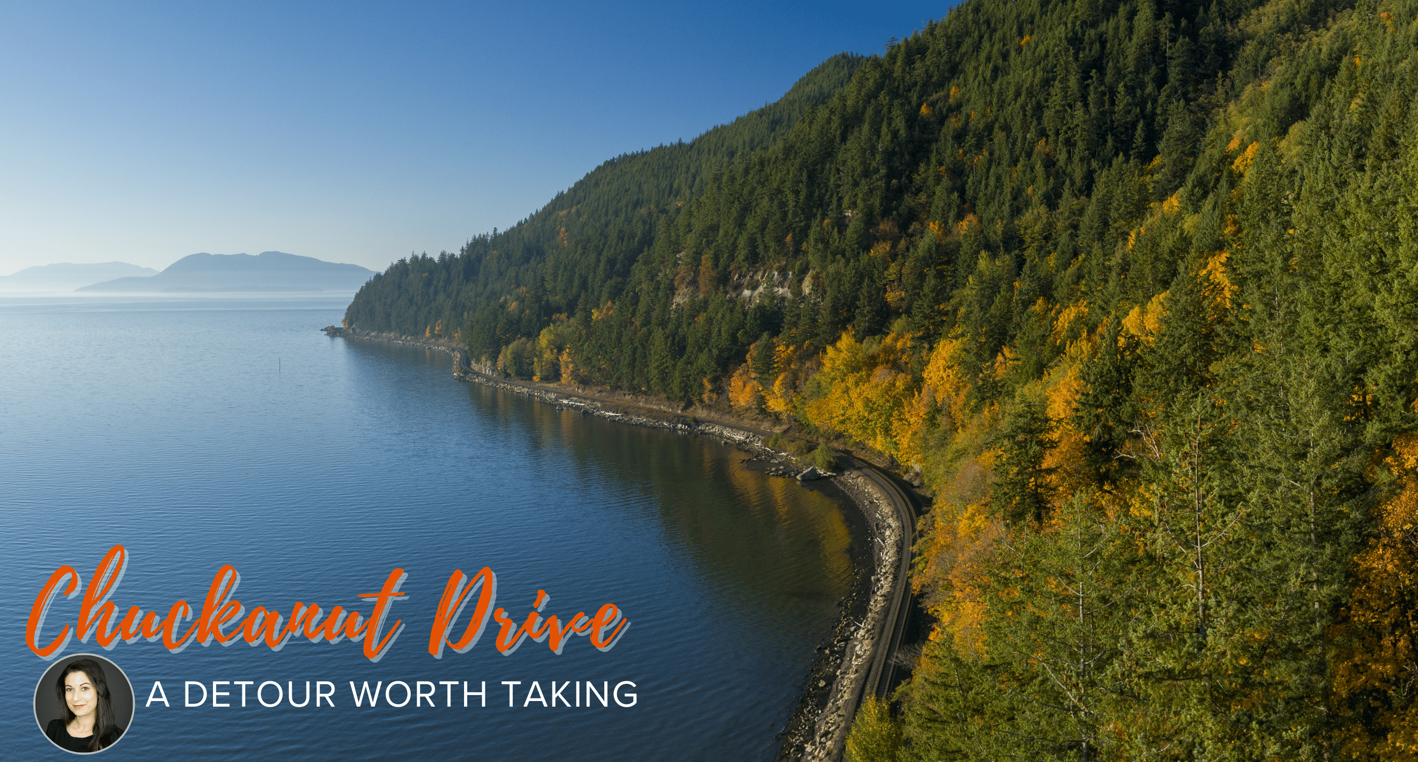
After living in Whidbey Island for a few years I finally decided to venture out and take the cliff-hugging drive along the Chuckanut Drive, a detour worth taking.
SR11 is a 21.28-mile-long highway that serves Skagit and Whatcom counties, in Washington.
I started the drive in Edison, the town of kindness, and made my first stop at the Breadfarm. If you love carbs as much as this Italian gal, you will be in love with this bakery. Founded in 2003, Breadfarm is an artisan bakery focused on the production of rustic loaves of bread and pastries, only using high-quality natural and organic ingredients. I just love their olive baguettes, ham & cheese croissants, herbed focaccias, and thumbprint cookies!


Once leaving the town of Edison I proceeded to Chuckanut Drive to begin my scenic tour.
Here are my 5 top recommendations for the Chuckanut Drive:
- Rhododendron Cafe – This is a popular cafe’ and restaurant which features a monthly rotating menu’, with cuisine from different parts of the world.
- Bat Caves Trailhead – A famous trail also known as the Oyster Dome Trail. It is a very steep and densely wooded trail but once you get to the top you will be able to enjoy views of the San Juan Islands and Samish Bay. Fun Fact: The bat caves are home to Townsend’s big-eared bats.
- The Oyster Bar – You will definitely enjoy an incredible view combined with an amazing lunch. Did you know? The Oyster Bar used to be a shack where oysters were sold to passing drivers.
- Taylor Shellfish Samish Farm Store – At this location, they have been growing oysters on about 1,700 acres of Samish Bay tideland for about 100 years. The shop sells clams, oysters, mussels, salmon and so much more.
- Clayton Beach – Clayton Beach parking lot is the access point to Larrabee State Park, Washington’s first state park in 1915. Larrabee State Park has 2,700 acres with two lakes, a campground, and miles of hiking trails.
I ended my excursion in Fairhaven, a town well known for its frequent festivals and Victorian charm. Filled with lots of artsy shops and delicious restaurants, Fairhaven is a popular tourist destination.
I particularly enjoyed the Iron Rooster Bakery with its traditional pastries, croissants, quiches, and my beloved macaroons!
Have you taken this drive? If so, do you have any recommendations for the next time I go?
Click here https://www.scenicwa.com/chuckanut-drive for more info.
If you enjoyed this blog you might also like:

Farmers Markets on Whidbey
Drinking Water on Whidbey Island

Where Does Your Drinking Water on Whidbey Island Come From?
WATER IS A PRECIOUS COMMODITY
As Whidbey’s premier real estate brokerage, Windermere agents get asked about our Island’s drinking water A LOT! Why? Water is a precious commodity, and one of the essentials of life. Knowing where your water comes from should be a primary concern of someone thinking about living on an island.
WATER ON WHIDBEY ISLAND
Many people who move to Whidbey have never experienced life with a well and even those who have rarely understand the implications that a well surrounded by saltwater might have. With the exception of the City of Oak Harbor and NAS Whidbey Island, who get all their drinking water piped in from the Skagit River (yes, it travels under the Deception Pass bridge), the rest of the island depends on tapping into our skinny Island’s network of underground aquifers.
WHAT IS AN AQUIFER?
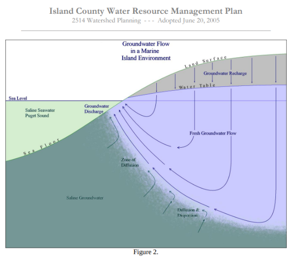
Think of an aquifer as a of pocket of freshwater, or more like a saturated sponge. Under the surface, sometimes DEEP under the surface, these pockets have enough permeability to absorb new water that seeps through the layers of dirt, rock, and gravel of the ground but can also store enough water to keep from running dry. Maybe a visual would help…
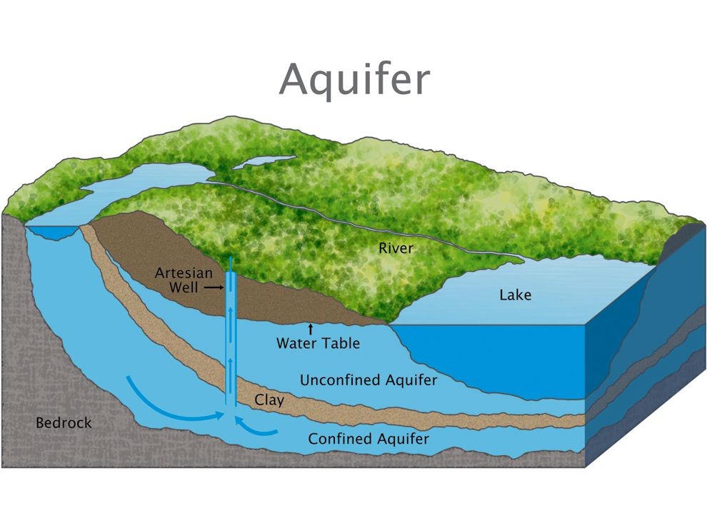
The problem with the graphic above for Whidbey Island is we are not on bedrock and we have very few large lakes. In fact, we are surrounded by saltwater which can become a real issue for saltwater intrusion when removing a large amount of freshwater from an aquifer too quickly.
WHAT IS SALTWATER INTRUSION?
Saltwater intrusion is a condition in which saltwater enters an aquifer and contaminates the water supply. The intrusion occurs when too much water is pulled from the aquifer, too fast. The reduction in pressure pulls in saltwater from the surrounding shoreline, ultimately contaminating the freshwater. Take-a-look at the graphic below for a better understanding.
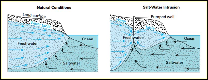
Source: https://www.usgs.gov/media/images/process-saltwater-intrusion
HOW TO PREVENT SALTWATER INTRUSION
One way to prevent saltwater intrusion is to slowly and steadily remove freshwater from the aquifer and store it so when demand spikes, like during summer, the sucking from the aquifer doesn’t become so intense that it pulls the saltwater in. Think of a straw poked into the pocket of freshwater. If you suck too hard it will pull saltwater in from the surrounding sea.
Another important activity is to regularly monitor wells across the island and collect enough data to see signals of wells that have a higher risk of saltwater intrusion than others.
HOW IS IT PREVENTED ON WHIDBEY?
Here in Island County, we are so incredibly lucky to have a full-time hydrogeologist, Doug Kelly. Doug has a very rare and critical position. He has helped develop a data-gathering system and monitoring program that helps to give Island County residents early warning signs if their well is at risk and provides them with steps to take to prevent that from happening.
WHERE DO I GO TO FIND OUT MORE?
There is a phenomenal database that anyone can access on Island Counties website called ICGeo and with the layer for wells turned on you can see where all the wells on Whidbey are located. Within a few clicks, you can also get a report that is hyperlinked with all sorts of additional information and a great color code to quickly gain a bunch of info on the health of the water.
If this gets too confusing and you want info on a specific well just call your trusty Windermere Real Estate Broker! If you do not have one of these gems already, call us today!
Oak Harbor 360.675.5953
Coupeville 360.678.5858
Freeland 360.331.6006
Langley 360.221.8898
If You Enjoyed Reading This Blog You Might Also Like:

>
